
 ..............................................
 |
.............................................. |
Annual Report 2002
Chalmers / Radio- and Space Science
Space Geodesy at Onsala Space Observatory
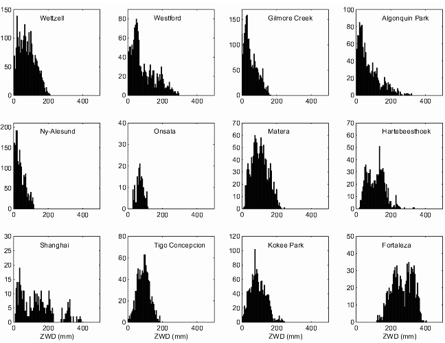
Figure 1: Histograms of the zenith wet delays for the VLBI stations
participating in the IVS-R1 and IVS-R4
series.
 |
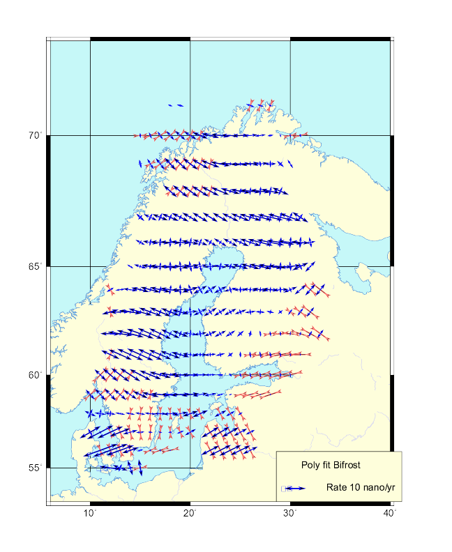 |
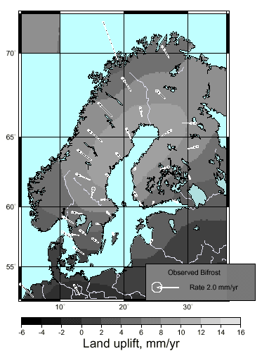
Figure 2: The map on the left shows the observed crustal motion in the
BIFROST GPS network, vertical component
by gray tones and horizontal components by arrows. In the map on the
right the deformation component has
been extracted. Strain rate crosses signify the two principal components.
We find extension in the central uplift
area at 5-10 ×10-9 yr-1 .
 |
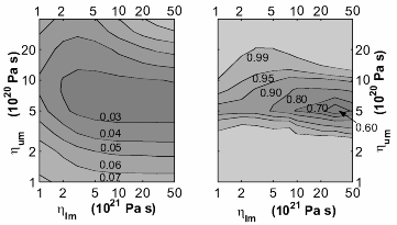 |
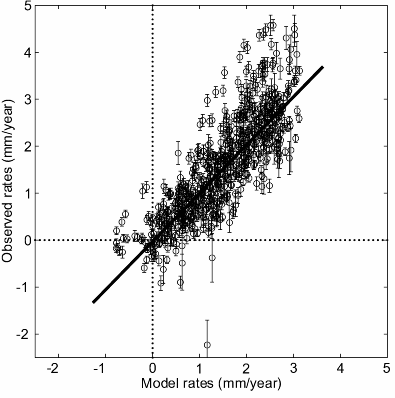
Figure 3: Comparison of baseline extension between a model for the Fennoscandian
glacial isostatic adjustment
(GIA) and BIFROST GPS observations in the left diagram reveals that
the landuplift appears to be the dominating
cause also for length changes, other causes including systematic errors
in the observations being statistically rare
or confined to within 1 mm/yr. In the right two diagrams the misfit
between different GIA models and the
observations is used to determine the best fitting set of mantle viscosity
parameters. Viscosities are varied in
lower mantle as shown along the abscissa and upper mantle along the
ordinate, respectively. We show the mean
square error in the centre and a Fisher F-test in the right.
(a) |
(b) |
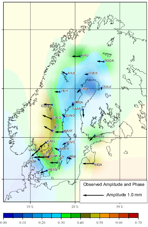
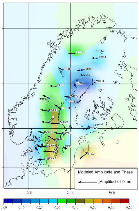
Figure 4: Estimated amplitude and phase of the diurnal component in
the atmospheric water vapour content for
five consecutive summers (a) from GPS data (b) from a climate model
(from [21]). Each vector represent the
result from one GPS site. The diurnal amplitude is described by the
length of the vectors. The phase is illustrated
by the vector direction in a clock-wise sense and up means 0 hours
(midnight) and down means 12 hours (noon).
We see that for most of the sites the maximum IWV occurs in the late
afternoon.
[2] Bergstrand, S.,
GPS - Superficial Observations for Deeper Knowledge of
the
Earth, Technical Report No. 256L, Licentiate Thesis at
the School of Electrical and
Computer Engineering, Chalmers University of Technology,
Göteborg, 2002.
[3] Bouma, H.,
Ground-Based GPS in Climate Research, Technical Report
No.
456L, Licentiate Thesis at the School of Electrical and
Computer Engineering,
Chalmers University of Technology, Göteborg, 2002.
[4] Elgered, G., D. Behrend, R. Haas, and H. Bouma,
Atmospheric effects on the VLBI results,
In Campbell, J., R. Haas and A. Nothnagel (eds):
Measurement of Vertical Crustal
Motion in Europe by VLBI, pp. 14-29, European Commission
Research Networks,
Training and Mobility of Researchers, Geodetic
Institute, University of Bonn, 2002.
[5] Elgered, G. and B. Stoew,
The IVS Technology Development Center at the Onsala
Space Observatory.
In Vandenberg, N.R., Baver, K.D., International
VLBI Service for Geodesy and
Astrometry 2001 Annual Report, NASA/TP-2002-210001,
2002.
[6] Gradinarsky, L.,
Sensing Atmospheric Water Vapor Using Radio Waves,
Technical Report No. 436, Doctoral Thesis at the School
of Electrical and Computer
Engineering, Chalmers University of Technology, Göteborg,
2002.
[7] Gradinarsky, L.P. and P.O. Jarlemark,
GPS tomography using the permanent network in Göteborg:
Simulations.
Proceedings of the IEEE Positioning and Navigation
Symposium, pp.128-133,
Palm Springs, USA, 2002.
[8] Gradinarsky, L.P., J.M. Johansson, H.R. Bouma, H.-G.
Scherneck, and G. Elgered,
Climate monitoring using GPS,
Physics and Chemistry of the Earth, 27, 335-340,
2002
[9] Haas, R. K.-Å. Johansson, G. Elgered, S. Bergstrand,
L.P. Gradinarsky, B. Stoew,
H. Bouma, and M. Lidberg,
The IVS Network Station Onsala Space Observatory.
In Vandenberg, N.R., Baver, K.D., International
VLBI Service for Geodesy and
Astrometry 2001 Annual Report , NASA/TP-2002-210001,
2002.
[10] Haas, R., H.-G. Scherneck, M.S. Bos, J.M. Johansson,
and L.P. Gradinarsky
The IVS Special Analysis Center at the Onsala Space
Observatory.
In Vandenberg, N.R., Baver, K.D., International
VLBI Service for Geodesy and
Astrometry 2001 Annual Report, NASA/TP-2002-210001,
2002.
[11] Haas, R., Scherneck, H.-G., Gueguen, E., Nothnagel,
A., and Campbell, J.,
Large-scale strain-rates in Europe derived from
observations
in the European geodetic VLBI network,
EGU Stephan Mueller Special Publication Series,
2, 139-152, 2002.
[12] Haas, R., and P. Tomasi,
Results of the Geodetic VLBI Observation Program.
In Campbell, J., R. Haas and A. Nothnagel (eds):
Measurement of Vertical Crustal
Motion in Europe by VLBI, pp. 98-102, European
Commission Research Networks,
Training and Mobility of Researchers, Geodetic
Institute, University of Bonn, 2002.
[13] Jarlemark, P.O.J., J.M. Johansson, B. Stoew, G. Elgered,
Real time GPS data processing for regional atmospheric
delay derivation
Geophys. Res. Letters, 29, DOI 10.1029/2001GL014568,
2002.
[14] Johansson, J.M., J.L. Davis, H.-G. Scherneck, G.A.
Milne, M. Vermeer, J.X.
Mitrovica, R.A. Bennett, G. Elgered, P. Elósegui,
H. Koivula, M. Poutanen, B.O.
Rönnäng, and I.I. Shapiro
Continuous GPS measurements of postglacial adjustment
in Fennoscandia, 1.
Geodetic results,
J. Geophys Res., 107, DOI 10.1029/2001JB000400,
2002.
[15] Lidberg, M., Haas, R., Bergstrand,
S., Johansson, J., Elgered, G.,
Local Ties Between the Space Geodetic Techniques
at the Onsala Space Observatory,
2002 General Meetings Proceedings, International
VLBI Service for Geodesy and
Astrometry, Tsukuba, Japan, NASA/CP-2002-210002,
eds. N.R. Vandenberg, K.D.
Baver, NASA, Hanover, MD, pp. 91-95, 2002
[16] Lidberg, M., J.M. Johansson, and H.-G. Scherneck,
Re-computation of the BIFROST GPS networkand study
of possible periodic effects.
In Poutanen, M., and H. Suurmäki (eds): Proceedings
of the 14'th General Meeting
of the Nordic Geodetic Commission, pp. 66-70, Geodeettinen
Laitos, Kirkkonummi,
2002.
[17] Lidberg, M., Ch. Steinforth, R. Haas, and A. Nothnagel,
Local tie measurements at Ny Ålensund - a
status report.
In Poutanen, M., and H. Suurmäki (eds): Proceedings
of the 14'th General Meeting
of the Nordic Geodetic Commission, pp. 94-98, Geodeettinen
Laitos, Kirkkonummi,
2002.
[18] Nothnagel, A., D. Behrend, S. Bergstrand, B. Binnenbruck,
R. Haas, and Ch. Steinforth,
Local survey ties at VLBI observatories.
In Campbell, J., R. Haas and A. Nothnagel (eds):
Measurement of Vertical Crustal
Motion in Europe by VLBI, pp. 62-97, European Commission
Research Networks,
Training and Mobility of Researchers, Geodetic
Institute, University of Bonn, 2002.
[19] Scherneck, H.-G.,
BIFROST Project: Observing the postglacial rebound
in Fennoscandia
using continuous GPS.
Comptes rendus 89'ieme Journées Luxembourgeoises
de géodynamique, ECGS,
Luxembourg, in press, 2002.
[20] Scherneck, H.-G.,
IVS Analysis Working Group for Geophysical Models
in VLBI software. In
Vandenberg, N.R. and K.D. Baver (eds): 2002 General
Meeting Proceedings,
International VLBI Service for Geodesy and Astrometry,
Tsukuba, Japan, pp.
398-400, NASA/CP-2002-210002, NASA, Hanover, MD,
2002.
[21] Scherneck, H.-G., and M.S. Bos,
Ocean tide and atmospheric loading.
In Vandenberg, N.R. and K.D. Baver (eds): 2002
General Meeting Proceedings,
International VLBI Service for Geodesy and Astrometry,
Tsukuba, Japan, pp.
205-214, NASA/CP-2002-210002, NASA, Hanover, MD,
2002.
[22] Scherneck, H.-G., R. Haas, and M.S. Bos,
Station Motion Model.
In Campbell, J., R. Haas, and A. Nothnagel (eds.)
Measurement of Vertical Crustal
Motion in Europe by VLBI, pp. 30-50, European Commission
Research Networks,
Training and Mobility of Researchers, Geodetic
Institute, University of Bonn, 2002.
[23] Scherneck, H.-G., J.M. Johansson, G. Elgered, J.L.
Davis, B. Jonsson, G. Hedling,
H. Koivula, M. Ollikainen, M. Poutanen, M.
Vermeer, J.X. Mitrovica, and G.A. Milne,
BIFROST: Observing the Three-Dimensional Deformation
of Fennoscandia.
In: Glacial Isostatic Adjustment and the Earth
System, edited by J.X. Mitrovica and
B.L.A. Vermeersen, pp. 69-93, Geodynamics Series,
Volume 29, American
Geophysical Union, Washington, D.C., 2002.
[24] Scherneck, H.-G., J.M. Johansson, R. Haas, S. Bergstrand,
M. Lidberg, and H. Koivula,
BIFROST project: From geodetic positions to strain
rates.
In Poutanen, M., and H. Suurmäki (eds): Proceedings
of the 14'th General Meeting
of the Nordic Geodetic Commission, pp. 62-65, Geodeettinen
Laitos, Kirkkonummi,
2002.
--
Prepared by Hans-Georg Scherneck on the basis of the section that the
Research group
for Space Geodesy and Geodynamics supplied for the Annual Report 2002
of the
Chalmers Centre for Astrophysics
and Space Science
Onsala, 2003-04-27.