You can send mail to  directly
The mail must be in
plain ASCII in all its parts.
Compulsory Subject line:
Subject:
Ocean Loading Tides
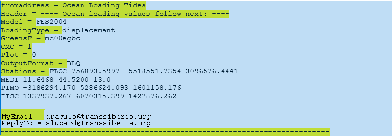
Compulsory text on yellow background.
The text must end with a long
sequence of minus-signs (NEW!)
reason for change: The MyEmail
line has frequently been lost in the processing
The equal-sign after a keyword must be surrounded by one whitespace
left and right.
ReplyTo = email@addr.ess
is optional (NEW!).
Its purpose is to distinguish the return address for results (MyEmail)
and diagnostic notifications.
In the case that results are not read by human beings, the ReplyTo
address would report to one.
The Header line must be exact
(a test against spam will weed out all mail not exactly reading like
this).
The Station lines:
You can follow the instructions on the web to fit the columns.
Stations = \n
NAME1
coordinate1
coordinate2 coordinate3\n
NAME2
coordinate1
coordinate2 coordinate3\n
...
\n =
<RET><LF>
On
a UNIX/Linux system you can use
printf "%-24s %15.3f %15.3f
%15.3f\n" $name $x $y $z
An alternative, shorter column
structure is: (NEWEST!!)
NAME coordinate1 coordinate2 coordinate3\n
ABCD_DOMENUMBR -1234567.890
-1234567.890 -1234567.890\n
ABCD
1234567.890 1234567.890 1234567.890\n
-------------------------------------------------------
1234567890123456789012345678901234567890123456789012345
1
2
3
4
5
up to 55 characters in
length, parameters separated by exactly one blankspace (no TAB
characters please!), and ending with a line feed.
If you need to specify a monument code, please
use the underscore-character to abut it (NEWEST!!)
Reason
for change: Some mail composers appear to add other kinds of
ASCII codes than the standard blankspace DEC32
Some users need domes identifiers. The underscore is for
decoding purposes; in the result file, the two parts are split
apart.
The first station line can also appear in the
keyword line, as
Stations = NAME
coordinate1 coordinate2 coordinate3\n
You can specify XYZ in
metre as in the example,
or longitude, latitude in
degrees (decimal point format, not minutes' seconds"), and height in meter.
At maximum 100 sites can
be processed in one request.
For
Model choose any of the following:
AG06
CSR4.0 EOT08a FES94.1
FES2014b
GOT99.2b
HAMTIDE TPXO.6.2 TPXO.7.2
DTU10
CSR3.0
EOT11a FES95.2 FES2012
GOT00.2 NAO.99b
TPXO.5
TPXO.7.1
EOT20 FES98 FES2004
GOT4.7
Schwiderski
TPXO.7.0
FES99
TPXO8
(check with the drop-down menu on the main page for recently
added models).
For LoadingType
choose any of the following
displacement .
nanoms2
(gravity and tilt in units nm/s2 and nrad)
mgal
(gravity
in units of mGal) (deprecated)
For GreensF choose among
mc00egbc
elastic
Gutenbeerg-Bullen earth model
STW105
PREM anelastic, frequency-independent Q
For CMC
choose any of the following
0
(reference
origin is solid earth centre)
1
(reference origin is joint mass centre earth+ocean)
For
OutputFormat choose any of the
following
BLQ
HARPOS
If you like to see plots
of the near-field coastline resolution, add a line
Plot = 1
preferably before the station information. After processing you will
find them here.
If you send mail from UNIX/LINUX using sendmail:
sendmail -t < request.txt
where request.txt starts with
To: loading@holt.oso.chalmers.se
From : your@address
Note the blankspace after "From". Continue as above
with "Subject:" etc.