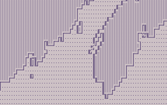
First an example. Notice the diagonal channels marked with u
and v as well as the twelve types of land
boundaries represented by neat MS-DOS line-drawing characters.

From left to right:
| Inland (the stippled symbol) | u=v=0, zeta=0 | 0 |
| East-coast | u+v=0, values to the east | 10 |
| North-coast | u-v=0, values to the north | 20 |
| West-coast | u+v=0, ... | 30 |
| South-coast | u-v=0, ... | 40 |
| NE-cape (sea to the NE) | v=0, values to the NE | 50 |
| NW-cape | u=0, values to the NW | 60 |
| SW-cape | v=0, ... | 70 |
| SE-cape | u=0, ... | 80 |
| SE-bay (sea to the SE) | u=v=0 | 90 |
| NE-bay | u=v=0 | 100 |
| NW-bay | u=v=0 | 110 |
| SW-bay | u=v=0 | 120 |
| u - sea connected (narrow passage open for SE-currents) | v=0 | 130 |
| v - sea connected (narrow passage open for NE-currents) | u=0 | 140 |
| / - land connected SW-NE (two bays (NW and SE)
back-to-back) |
u=v=0 | 150 |
| \ - land connected NW-SE (two bays (SW and NE)
back-to-back) |
u=v=0 | 160 |
There are flags carrying other meanings.
Click here
for hints how to view/print these arrays.
| Back to HOW_TO
| Back to General
Information |
.bye